It was a pretty uneventful run down to Key Biscayne. We just had to bother with those pesky bridge openings but that was no big deal. It was still very windy but didn't create much of a chop on the water. As we passed Miami we saw this helicopter sitting on a very small pad. While that was curious by itself, notice the two motors on the pad it is sitting on!!
We are planning on leaving for the Bahamas from Key Biscayne. Norm's sister, Joyce, also lives here so we will get to visit with her. We have had our mail forwarded to Joyce so we are looking forward to catching up with that.
We were not able to find a spot in the harbor of the state park, where we have stayed before, because of the large number of sailboats in there, probably like us waiting for weather to cross to the Bahamas. So, we anchored out the first night and the next day planned to take the dingy in to meet Joyce and have lunch with her. Unfortunately, the shores of Key Biscayne are all privately owned so there are no places to dingy ashore aside from the state park. We were told we could dingy to the church property not far from our anchorage but when we got there we were told we couldn't stay. Joyce was already at the church to meet us so Rick and I went with Joyce in her car and Norm and Vicki dingied all the way back to the state park which was quite a hike and the water was rough so they were drenched.
 Joyce gave us a great tour of Key Biscayne. We saw the site of the Nixon 'Southern' White House, along with the helicoptor pad, which, I assume one must have if one is the President. At any rate, the old Nixon house was torn down and a beautiful new mansion now stands in its place along with the helicoptor pad. There was some problem with the new owners having to do with drugs somehow and the government took the title to the mansion for several years. It was amazing to see all the huge mansions. Key Biscayne is a really beautiful place. We met up with Norm and Vicki and had a wonderful lunch at a local Italian restaurant.
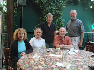
The winds were predicted to move around from the southeast and we weren't that well protected where we were so we came into a small harbor on the southwest side called Hurricane Harbor. It is well protected from the winds and is beautiful. Here are some sunset pictures that Rick took. The first was taken on Tuesday and the other 3 on Wednesday. Beautiful!


It looks like Tuesday, 3/31, is going to be a perfect day to leave for the Bahamas as the winds are predicted to die down and the seas will be calm . It is about a 6 hour trip from here. We are excited to finally be ready to go. There are 3 main island chains in the Bahamas. The northern- most chain is called the 'Near Bahamas' and includes Grand Bahama Island, Abacos, Bimini, the Berry Islands, Andros and Nassau. The second chain is called the Exumas and the most southern is called the 'Far Bahamas'.
We are headed to the Exumas. It is a chain of islands that stretches about 100 miles north to south. Unlike the Near Bahamas it is not very populated. We've talked with lots of other cruisers and they all say it is a beautiful place to fish, snorkel, swim and hang out. The down side is that internet service and phone service may be hard to find. So, we will update the blog as we can to let you know that we are having fun and have not fallen off the other side!! Below is one of the many dolphins that are here in the harbor. He came for a visit! 
Rick took these two videos of Hurricane Harbor. It was a bit windy so you'll hear that but it is such a pretty place, we wanted you to see it!
With this entry we have included a Google Map locator feature. When you click the link below it will take you to a Google Map page with a satellite image and pointer to our current location. You can zoom in or out and use the 'hand' to drag the map around for other views. If you close the white box (click on the X in the upper right corner), you can see the helicoptor pad for Nixon's Southern White House and also some of the roofs of the houses from the videos above.