We left Rhode Island on Saturday morning, July 17th, and headed east towards MA. For the first few hours it was pretty rolly but not too bad and the seas laid down for the rest of the day. It turned into a gorgeous day and every sailboat in RI/MA was out on the water! We were on our way to the Cape Cod Canal which is 10 miles long and cuts across the neck of Cape Cod to points north and east, saving us from going south around the Cape and contending with the Nantucket Shoals. On the way we learned from the charts that there are named bodies of water known as Block Island Sound and Rhode Island Sound which lie between Long Island Sound and the Atlantic. Over the last few days we have also noticed on the National Weather Service web sites that conditions on Block Island Sound and Rhode Island Sound seem to be exceptionally lumpy and windy; maybe from the prevailing SW winds and currents … anyway, just an observation … and minor lesson in marine geography.
We stopped west of the canal in the afternoon at a pretty little place called Onset Bay. We were officially in MA. We needed to go through the canal at slack water and that wasn’t until the next morning. We picked up a mooring ball and watched the activity for the evening. Because it was Saturday and a beautiful weekend, the Bay was full of boaters of every size and type. The coolest thing happened when we were at Onset. We were sitting on the deck in the evening and a trawler came by and a woman said ‘Illumination tonight’. We had no idea what that meant until the sun went down and the entire harbor rim was lit up with bright orange flares placed about 15 feet apart…including the 2 little islands in the harbor. What a sight that was and they lasted for about 45 minutes. The picture doesn’t do it justice but you get the gist.
Click here to see our location on Onset Bay


Beautiful Sunset Illumination
On Sunday we left at 9:00 am to hit the tide at the right time through the canal. There are 3 very tall bridges…one being a train lift bridge, across the canal. It is the second longest lift bridge in the world (over 500 ft) and was pretty impressive. The canal was really pretty. Lovely homes along the shore and walking and running paths (no cars) the entire 10 miles.


Going into the Cape Cod Canal No barge traffic today, only pleasure craft


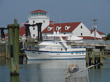
Passing by the Massachusetts Maritime Academy Cool windmill on MMA


Pretty homes along the shores of the Canal
Exiting the Canal we entered Cape Cod Bay and turned north to hug the shoreline as we made our way to our next stop, Scituate Harbor, just south of Boston. As are many areas in New England, Scituate was named after a local Native American.

Click here to see our location in Scituate Harbor
It was a very easy run to Scituate. The weather was cool and beautiful and the seas were calm. We dodged lots of lobster pots along the way but this is just training for Maine. It was crazy coming into the harbor. Looked like traffic on 95! Everyone wanted to get in a few more hours of boating before the weekend ended.


At least they were all fairly small!

The Scituate Lighthouse (have we mentioned we love lighthouses??)


Sailing school boats on their docks Pretty homes along the harbor


The photographer at rest Dramatic light as the sun goes down
As it was Sunday afternoon, the boat traffic changed dramatically as folks went home and it became calm and quiet. We enjoyed our stay there.
We left Scituate on Monday morning to go to our last stop in MA. We decided to bypass Boston on the way north but will catch it on the return trip. Lynnie’s nephew, Sean, lives there and we want to visit with him but we thought it made sense to head to Maine now and catch him on the way home (remember the short summers here). We had an easy, 3 hour, run to Salem, MA (the witch city as they call it here) where we have been on a mooring ball.


Coming into Salem, MA…pretty shoreline
Click here to see our location in Salem, MA
We were sitting on the aft deck (can you tell we do that a lot?) when this huge ship came into the harbor. We had no idea ships of this size would make it into this small harbor. It was delivering coal to the coal plant across the bay. We were amazed by how hard the tugs worked to get the ship into position. It looked like it was awfully close to us and it was about 1,000 feet long, and as it was being maneuvered by the tugs it was apparent that the tugs and a small pilot boat were “in charge.” A number of the crew were on the outside of the bridge watching, but it was pretty much in an idle state as the tugs moved it onto the coal plant docks.


Last night we took the tender to town and had a wonderful dinner. We just don’t think one can get enough lobster dinners. On the way in, the tender Capt. swung by the ship ‘Friendship’, a reconstruction of a 1797, three-masted Salem East Indian ship.