NOTE: We have decided to change our locator map to a cumulative map with little blue teardrops for the locations we have visited on the way north. The most recent port of call will be the first one on the list in the left hand pane. You can click on the list entry of any teardrop, and the Google map will show you that location. As usual, you can zoom in and out, and drag the map around as you wish. We will change the color of the teardrop when we turn around to begin the trek home. Thanks, Phil, for all your help with this!
Click hear to see the cumulative map, and our most recent port of call in Belfast, Maine.
We arrived in Rockland on Friday, July 30th. This is our first stop in Penobscot Bay. Many say that this is the most beautiful cruising ground in the world. We would have to agree. There are islands large and small (200 of them, just in Penobscot …!), lots of towns and harbors of all sizes and places to just throw down the anchor and sit for several days. We will be spending most of August between Penobscot Bay and the Gulf of Maine which is farther east and is where Bar Harbor and Mt. Desert Island are located.
We needed to take on fuel and do some provisioning and as the book says ‘Rockland is the big city ‘round these parts’! I think I would call it a big town but whatever you call it, Rockland had what we needed. We found diesel fuel for $2.40 a gallon which is a great price. In Boothbay it was $3.53/gallon! Anyway, we also received our mail for the first time in 6 weeks so after we fueled up Lynnie washed the boat and Rick did all the bills. (Neither chore was very much fun but we got it all done.)
The bestest part is that the weather has been fabulous! We woke up on Saturday and it was 74 degrees! Following are some pictures we took on the trip from Boothbay to Rockland and of Rockland.


Lots of small islands, most privately owned The scenery is just breathtaking


Portland Fire Boat


The picture above is of Owl’s Head and the lighthouse marking the entrance to Rockland


‘Downtown’ Rockland

Dingy Dock


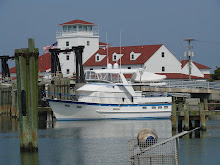
This is the breakwater which defines Rockland Harbor

We left Rockland on Sunday to make our way to Belfast, which we had heard is a pretty little town. When we woke up in Rockland on Sunday morning this small cruise ship, below, was in our marina. When we got to Belfast, it came into the harbor a couple of hours after we moored. Guess those folks aboard are getting a bird’s eye view of Maine!


Walking the streets of Belfast was pretty interesting!

An artist painted the windows and the water and cat coming out! Strange


This was a different kind of art but interesting all the same. Lots of artists in Maine


It was a stiff walk up hill to get to the laundromat and the grocery store


Rickshaw on her mooring ball

This morning when we woke up it was even cooler…64!! You’ve got to love it here. Like Lynnie’s aunt says ‘you have to be ready for any kind of weather in Maine’. Tomorrow it could be back in the 90’s.
We are leaving in the morning, Tuesday, to go hang out in some small harbors as we make our way to Mount Desert Island further to the east. We are looking forward to the next few weeks, and hanging out in gunkholes and out-of-the-way places, of which there are many. Tomorrow we’re headed for Bucks Harbor, 16 miles to the SE, at the north end of Eggemoggin Reach leading to Swans Island. You won’t find these on a map … probably only on a chart … but that’s one of the attractions of this place. After that, the Cranberry Islands await …